I woke at 5:30 to birds singing. It had not been cold AT ALL overnight. After a Mexican croissant and some cappucino (instant powder), I packed up. It was hard to feel the time of day, as it was heavily overcast. I probably left at 8:45 or so.
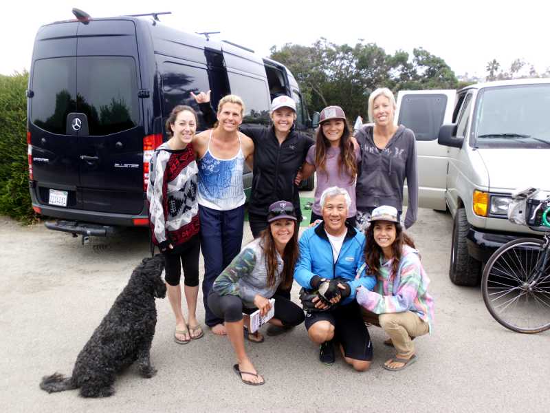
The previous day, I never did go over to talk with the surfer girls, but did wave to them as I was leaving, which led to some short conversation. Turns out, they’re all surfer moms, some who have known each other for a long time, and some who they just met in the beach. Lena’s whole family surfs, even the children, but this expedition was girls-only.
Although I had positioned my tent at maximum distance from their site, one of them said I snored. Yeah, I know. Sorry, ladies!
I stopped in Del Mar to use the public library. I’m beginning to realize how crucial libraries are to travelers, both for internet, and recharging. Fortunately, the library opened at 9:30, just 20 minutes after I arrived. I stayed until 11, knowing that the day’s ride should have been short.
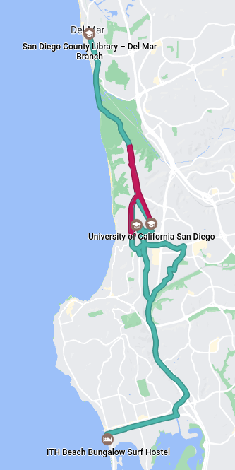
What should have been a simple 90-minute, 11-mile ride, turned into a frustrating, 5 1/2 hour, 31.3-mile ride. I’m tempted to tag this day as “hard,” but won’t. For each of the hard days, there were learnings. Learnings about Google Maps today: The chevron (arrow) indicates the direction of travel, not which way the phone is pointing. Maps for Bicycle will not tell you if you are going the wrong way. If you reach an intersection where you can only turn left, and Maps tells you to turn right, you are going the wrong way. If the distance to the next turn is going up instead of down, you are going the wrong way. If the time to destination is going up, you are going the wrong way.
Some of the difficulty is my own doing, either by stupidity or design. For example, I’m continuing to carry a full gallon of water in my packs, even though there has been ample water since San Luis Obispo, and the space and weight could have been used for other things on this segment. There will be no water spigots in the desert.
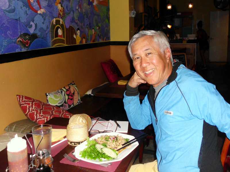
It ended well. The hostel is nice, my shoes are so comfortable, and the Desitin worked. I had a shower here, then walked out to Thai Coconut restaurant, which was actually owned by Laotians.
I’m spending a full 3 days here, to gather supplies, strategize, and attend church.
Miles: 55 (estimate, including getting lost)
Hi Roderick,
I may be overlooking the obvious, but it seems many problems you encountered in navigation and planning could have been avoided with a smart phone with an appropriate data plan. Then again, if you had wanted things to be *easy* you could have also driven, so I don’t know where to draw the line between smart planning/comfort and challege/experiences. One could argue that a smart phone gives you more choices, flexibility, and connection. Then again these are not necessarily good things, depending on your mission.
Reuben
I actually have an Android phone with me, but am just learning how to use Google Directions for bicycles. I was doing a two-finger pinch and spread like for Apple, but it was fidgety, until I realized that I could double-tap to zoom in, tap and drag to zoom in/out. Also, the mapping for bicycles is officially Beta, and leaves a LOT to be desired. Any bike paths in the area pull the route like a magnet. For example, that crazy loop around on unmarked bike paths through the University could have been bypassed if I just stayed on Torrey Pines Rd, which would have intersected Gilman road, where I wanted to be. It did the same thing to me in Huntington Park, turning me in circles on the twisty bike paths. I finally reverted to paper maps. Also, unlike Google Directions for cars, the App won’t tell you to turn around, or that you’re going the wrong way. And maps for bikes can’t be pre-loaded the same way car maps can. Maybe the street maps are in one place, and the bike paths are in another database? On regular streets, the App does all right.
As for things being hard, I’m not really looking for this much Adventure. But I think the troubles are necessary, and again, it’s better to have them now than in the Sonoran Desert. Navigation troubles have mainly been in urban areas, when I have tried to rely on GPS rather than my paper maps. Should be better once I get away from big cities.
This sort of brings to mind the movie Ten Commandments, when Moses is banished to the desert. He needs to walk through the fire, to purify and strengthen him for the task ahead.
Maybe try these (works on my phone):
1 From Settings/(Personal) Location/Mode select “high accuracy”
note this drains your battery faster, but if you only turn on your phone when you need it, this wont be so bad. besides, when you do need it, you probably want your location as accurate as possible
2 open Google Maps. If the blue dot marking your location has a large diameter ring (imprecise), extend your arm, and wave your phone in a large figure 8 several times to calibrate your compass. giving it the best precision may help direction responsiveness.
3. download a compass app. never know when you are away from cell and wifi, or GPS is unreachable (happens sometime) then at least you have a compass (unless you got a real one).
1. On the two times I got lost using Maps, I drained the battery. I had to unpack the USB charger from my panniers, which means unstrapping the load on top of the rack, then unrolling the pannier top. That’s the weakness of these fully waterproof panniers. No side pocket that I can access with a zipper. And only so much will go in the front pack. Even in “high accuracy” mode, Google for bikes has led me astray by telling me to (say) turn right onto an unmarked path, when there were several choices.
2. Good idea, I’ll try it next time.
3. I have a real compass. No way am I relying on electronics whose battery can die, that can get baked to death in the sun, or flooded in the rain.
btw it only takes about 25 feet / several seconds walking before Map recognizes I did a 180. get tuned before turning east. best.
The phone absolutely recognizes which direction I’m going, as indicated by the chevron. Trouble is, unlike the driving GPS, it doesn’t tell me to turn around. It just silently lets me go wherever I want. What I want is a setting that will say, “Wrong way, Stupid!” or “You missed the turn, Moron!”
Reading your posts is a great exercise in reveling your own filters. What I read was… hanging out with cool surfer Moms, beautiful flowers, abundance of water and wonderful inexpensive lodging. Oh and (lots of background noise) something about navigation 🙂
I know it is hard Roderick, but safe travels and keep writing… This is awesome!
The picture looks like the Surfer Moms were close with me, but I actually didn’t get to meet them until I was already packed up on the bike and heading out. They were just your type – really friendly to strangers, and totally up for a picture.
I do love the way that you see the positive in everything, and your encouragement means the world to me.
Doing some catch-up… looks like you’ve had more misadventures. Sorry to read that.
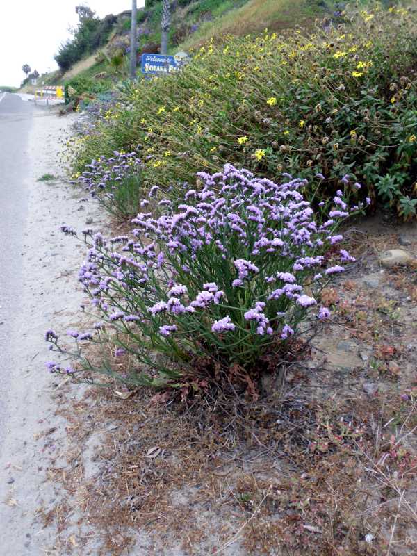
Statice grows “wild” locally, too… right now it is in bloom at Los Gatos Creek CP, on the east side of the creek. I’m not convinced that it is a native CA species, though… I tried researching it, and I think it is a Mediterranean native, Limonium sinuatum. Still quite colorful and pretty in the spring, though, and well adapted to our area. (No irrigation on that side of the park, so far as I can tell; everything there is native and drought tolerant.)