When the lot was initially purchased, there was no such thing as Internet. Land line service only. Maybe 300 baud modem to a dedicated mainframe.
In the early 2000’s when the lot passed to us, dial-up modem at 56 kbps would have been de rigueur. It was too far from the central office of the phone company for DSL, and there wasn’t (and still isn’t) any TV cable. At the time, I was thinking satellite would be the best way to go. Some people had microwave links, but they were quite expensive.
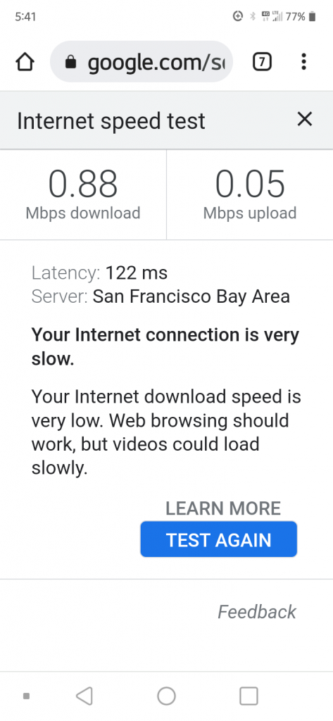
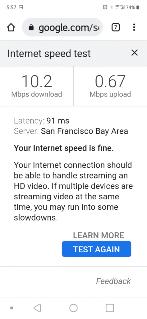
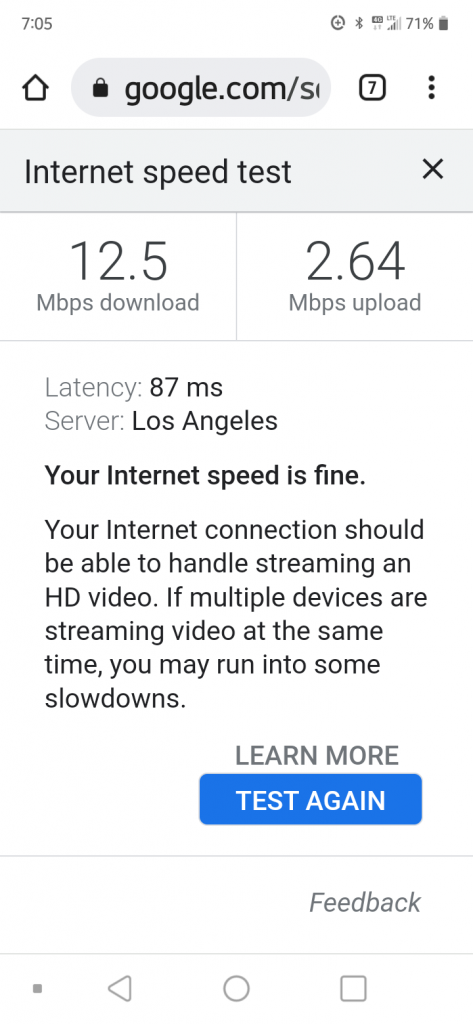
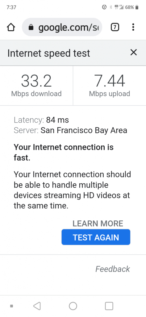
But now, several cell towers have gone up in Ocean View, the most massive multi-antenna complex near Palm Parkway and Reef Parkway. My 5g phone connects fine. That could be the ultimate internet source, with an unlimited data plan. Here are the speed test results:
This was at the site where I want to build a sun shelter. The location is in a broken lava tube of sorts – in other words, in a mini valley. Terrible data rate. But I could make a clear phone call to Honolulu, and presume that texts would be reliable, too.The lot has a little mountain on it. This test was run from the highland. It’s decent, enough for streaming video. This is where a cabin would be built, if ever. But thinking about it, maybe an antenna sticking up just 20 feet or so in the lowland would be enough to get line-of-sight to the cell tower. Or, I could get internet here, and beam it over to the lowland via wi-fi.This reading was taken from above the road in Ocean View Estates, 1.0 mile from the cell tower.I took this reading from the Pineapple Cabin, near the ridge of Ocean View Estates. It’s further from the cell tower (2.15 miles as the crow flies). This test was at 7:37 pm, after dark. The previous test was at 7:05 pm, still the edge of twilight. It could be that the cabin has clear line-of-sight to the tower, while the previous reading, though geographically closer, may have had obscuring trees or terrain. 33/7 is better than I get through ADSL2+.
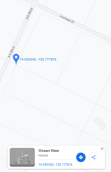
Years ago, I had the notion that I would have to pay a surveyor to mark the corners of the lot before building. But then my friend reminded me that I have a GPS in my pocket (my phone), and Google Maps shows the lot boundaries.
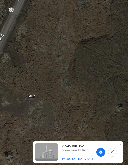
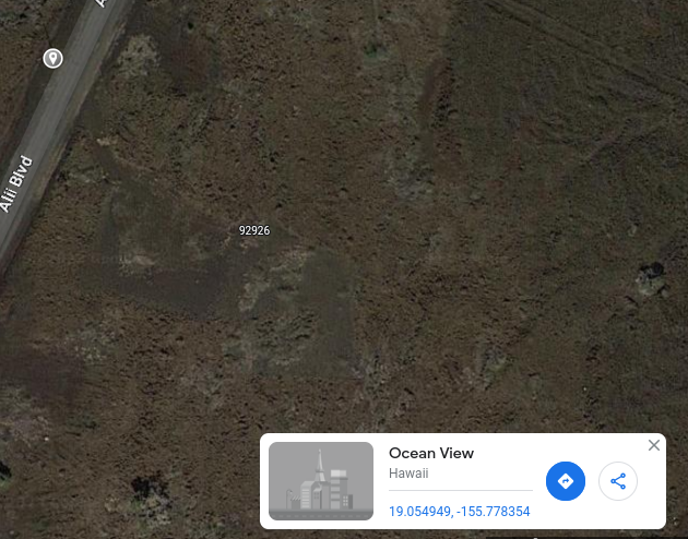
This is the north corner of our rectangular lot, which is tilted about 26 degrees off due north-south. Note the outline of our neighbor’s house in the adjoining lot to the east. The latitude is less than the Earth’s tilt of 23 degrees, meaning that this location gets Lahaina Noon (sun directly overhead) at some rare times of the year, and even sun coming out of the north.North corner again. Slightly different coordinates due to zoom and inexact positioning of mouse.West corner.South corner.East corner.This is the West corner in satellite view. I adjusted the brightness curves in Gimp for better visibility of terrain features (compare to satellite pictures below). The dark area to the northeast of the Google marker seems like a good location for a sun shelter. I don’t want to put a dwelling there, though. I want it in the dark area at the right of the picture, at the back of the lot, isolated. That area is actually on a small hill. The thing that looks like a road there is a bulldozer path at the lot line. It stops at the edge of a cliff.Looking closely, there are telephone poles across the street, roughly at the lot boundaries. I will first confirm their coordinates on the ground, then possibly use them as landmarks. This pole is across from the North corner.The pole across from the West corner.
Google Maps doesn’t seem to be the best tool for finding GPS locations while on the ground. I downloaded something called “GPS Data” for Android, which seems much better.
I created this blog with the intention of building something on the small plot of land that we have on the Big Island of Hawaii. But then the Pandemic hit.
There’s a little bit on the Ocean View Ranchos lot in the New Zealand Blog.